Published On Jun 9, 2024
Pathfinding algorithm visualised on a map of Barcelona, Budapest, Berlin and Amsterdam using A* (A-Star) with Euclidean distance as a cost.
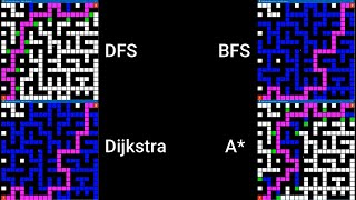
Sharing my study on the pathfinding algorithms and the results. Using the A star algorithm we can play around with a few variables to get different results. We can change what we count as the cost and how we calculate the guess or heuristic for this algorithm.
You can find all the other explorations on this topic here • A* (A-Star) Pathfinding Algorithm Vis...
Subscribe to my channel: / @nicogsplayground
Instagram: / nicogs
Threads: https://www.threads.net/@nicogs
Twitter: https://x.com/nicogsworld
Original Reddit post: / n4ukhhzmx7
Thanks to Martin Raifer and his Overpass Turbo tool which I used for the initial data where intersections of streets represented as nodes and streets as edges
DISCLAIMER
Any unauthorized use, reproduction, or distribution of this content incurs a €5,000 fee. By using this content without authorization, you agree to this fee and are legally bound to these terms. The owner reserves the right to take legal action for enforcement and compensation.
A* (A-Star) Pathfinding Algorithm on a real map (created in Javascript)
#pathfinder #graphtheory #dijkstra #pathfinding #algorithm
A* pathfinding algorithm, A Star algorithm visualization, street map animation, OpenStreetMap A* algorithm, OSMnx pathfinding, Chebyshev distance heuristic, Pathfinding algorithm visualized, A* algorithm city streets, Algorithm animation Barcelona, Heuristic pathfinding animation, Neural network visualization, Algorithm visualizations
AI pathfinding, Data visualization animation, Machine learning animations, Graph theory visualizations, Computer science animations, Geospatial data visualizations, Interactive data visualizations, Satisfying algorithm animations