Published On Mar 15, 2017
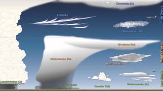
Most of us see clouds every day, but only very occasionally will you be lucky enough to spot one of these 7 particularly rare types - some of which can only be seen in very specific circumstances or locations.
Noctilucent clouds
One of the rarest and most beautiful of all cloud types. They are found at very high altitudes – up to around 250,000 feet Visible on clear, summers nights between 45 °N and 80°N latitude ,they appear illuminated by a blue or occasionally red or green light. We still do not know much about how they are formed, but they are thought to be made up of ice crystals.
Kelvin-Helmholtz clouds
They can sometimes be seen as far as 60 miles downwind of the mountains that formed them. An extremely rare phenomenon, where clouds form as a billowing wave pattern Occurs when there is a strong vertical shear between two air streams. This causes some winds to blow faster at the upper level, than at the lower level.
Mammatus clouds
Bulge or pouch shaped, they’re usually seen emerging from the anvil at the top of cumulonimbus clouds. Formed by turbulence, they are one of the few clouds that come from sinking, rather than rising air.
Lenticular clouds
Usually formed behind hills or mountains, where the air is stable and winds are blowing from a similar direction. These tall geographic features interrupt the wind, the airflow undulates and condenses into these disc shaped clouds.
Funnel clouds
Cone shaped clouds which extend from the cloud base, but never actually touch the ground. Formed in the same way as a tornado around a small area of intensely low pressure. If a funnel cloud reaches the land it becomes a fully fledged tornado and if the funnel cloud reaches the surface of a body of water, it becomes a waterspout.
Fallstreak Hole clouds
Also known as a hole punch cloud - they form when part of the cloud layer turns to ice crystals which are large enough to fall. Water droplets in the cloud, cooled below 0°C but not yet frozen, will freeze if they find a particle to freeze on to or are cooled to below -40°C. Aircraft can cause this to happen by making the air expand & cool as it passes through the cloud
Arcus cloud
Formed when warm air within a storm cloud is pushed up from the ground by the cold air exiting downwards. Unattached to the storm cloud they are known as roll clouds, but when attached they are called shelf clouds.
You may also enjoy:
– Podcasts exploring weather and climate • Weather podcast series
– Daily weather forecasts • UK national weather forecast
– Deep dive in-depth forecasts • Deep Dive Forecast UK
Make sure you subscribe so you never miss a single lesson about the weather or climate https://www.youtube.com/c/MetOfficeLe...
We are the Met Office, the UK’s national weather service, and every day of the week we bring you a morning weather forecast and an afternoon weather forecast so that wherever you are in the UK we have you covered. Forecasts and any weather warnings are accurate at time of recording.
To ensure you have the most up to date weather information, check the hourly forecast and live warnings on the Met Office website or app.
Credits
Intro: FREEMEDIABANK - • Sky with clouds. Relaxing background. Noctilucent clouds Kevin Lewis - • Timelapse of Noctilucent Clouds over ... Timow2s - • Noctilucent Clouds Kelvin-Helmholtz clouds Benjamin Brown-Steiner - • Kelvin-Helmholtz Cloud Time Lapse Diana Armendariz - • WAVE CLOUDS seen over Phoenix, AZ (Ke... keidashs - • Kelvin-Helmholtz Wave Clouds Mammatus clouds GenePoolChlorine - • Video Ronan O Keeffe - • Lenticular clouds Bazmo75 - • Lenticular Clouds - Dublin Funnel clouds xxRosalynLxx - • Funnel Cloud (Small Tornado) South We... Steven Harman - • St. George Island - Funnel Cloud Fallstreak Hole clouds Barry Morwood - • Weird cloud formation over Oshawa, On... Mad Astronomer - • Video Arcus clouds piratefux - • Shelf Cloud über Karlsruhe, 21.06.2012 Marcelo Albuquerque - • Roll Cloud Music: We Remain by Cocolixe